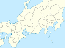
1858 Hietsu earthquake
Appearance
| Local date | April 9, 1858 |
|---|---|
| Magnitude | 7.1 M[1] |
| Epicenter | 36°24′N 137°12′E / 36.4°N 137.2°E[1] |
| Casualties | 426[1] |

The Hietsu earthquake (飛越地震, Hietsu jishin) was a doublet earthquake that took place on April 9, 1858 (according to the old Japanese calendar, the 26th day of the second month of Ansei 5). It most likely occurred on the Atotsugawa and Miboro faults,[2] which connect the Amō Pass in Gifu Prefecture (in the part that was called Hida Province) and Mount Tate in Toyama Prefecture (then known as Etchū Province) on the island of Honshū in Japan. Its name includes one kanji from Hida (飛騨国) and one from Etchū (越中国). The earthquakes are estimated to have killed 200–300 people. It also caused the Mount Tonbiyama landslide and blocked the upper reaches of the Jōganji River.[3]
See also
[edit]References
[edit]- ^ a b c Utsu, T. (2004). "Catalog of Damaging Earthquakes in the World (Through 2010)". IISEE. Retrieved 13 November 2011.
- ^ Komatsubara, Taku (28 May 2015). "Epicenter of the Ansei Hietsu Earthquake in 1858 inferred from ratio of dead persons in each village". Japan Geoscience Union.
- ^ Inoue K., Mizuyama T. & Sakatani Y. (2010). "The Catastrophic Tombi Landslide and Accompanying Landslide Dams Induced by the 1858 Hietsu Earthquake". Journal of Disaster Research. 5 (3): 245–256. doi:10.20965/jdr.2010.p0245.
External links
[edit]- 飛越地震(岐阜県防災局) (Hietsu jishin (Gifu-ken Bōsaikyoku)), Gifu Prefecture
- 飛越地震による大鳶山、小鳶山の大崩壊—災害伝承情報データベース (Hietsu jishin ni yoru Ōtonbi-yama, Kotonbi-yama no dai hōkai—Saigai denshō jōhō database), Ministry of Internal Affairs and Communications

